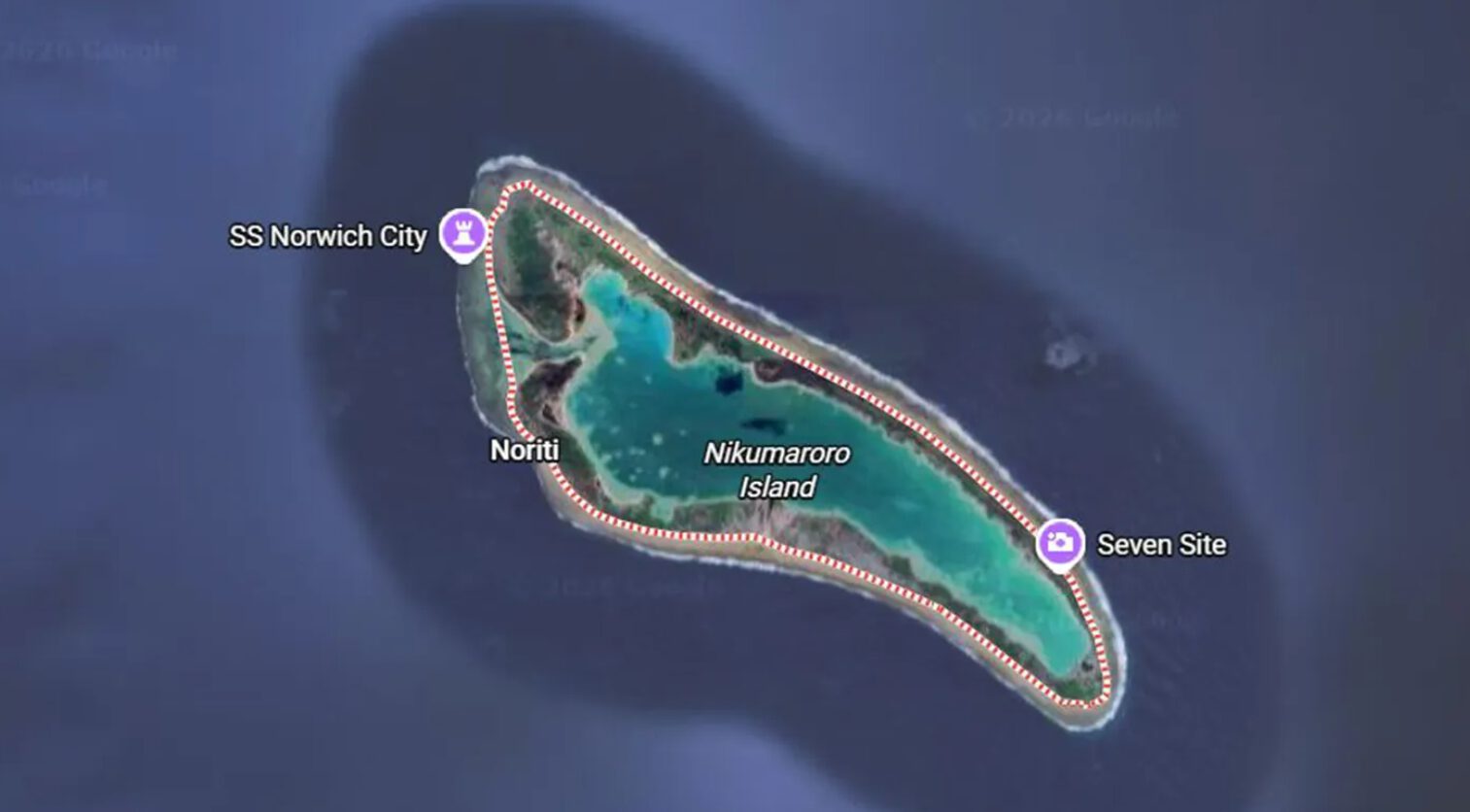
Dead-end historical mysteries just got crowdsourced. Pilot Justin Myers spent his downtime browsing Google Earth’s satellite imagery of a remote Pacific atoll, inspired by a National Geographic documentary about Amelia Earhart. What he spotted on Nikumaroro Island’s Taraia Peninsula has aviation archaeologists buzzing: objects that potentially match the dimensions of Earhart’s missing Lockheed Electra 10E.
Myers identified:
- A 50-foot sandy section
- A straight dark object resembling fuselage
- What appears to be a radial engine
- A half-exposed wheel
These aren’t random debris patterns—according to Myers, they align with the aircraft that vanished during Earhart’s 1937 circumnavigation attempt, though definitive confirmation awaits professional investigation.
Professional Validation Follows Amateur Discovery
Scientists confirm citizen discoveries deserve professional investigation.
Dr. Richard Pettigrew from the Archaeological Legacy Institute isn’t dismissing Myers’ desktop detective work. “I’m a scientist,” Pettigrew told the Today show in October 2025. “There’s such a huge amount of evidence that I believe we’re on the right track.” His team supports the theory that Earhart force-landed on Nikumaroro’s northwestern reef before her plane sank into the Taraia Peninsula.
Purdue University researchers are planning a November expedition to investigate what they call the “Taraia Object”—an anomaly visible in satellite photos since 1938. They’re bringing sonar equipment, magnetometers, and dredging gear to examine what Myers spotted from his computer screen.
The New Age of Citizen Science
Accessible satellite imagery turns anyone into an archaeological investigator.
Myers took the careful approach, filing his observations with Australia’s Transport Safety Bureau without claiming definitive discovery. “All I am saying is that these objects look like unfound plane wreckage, which strangely looks and measures the same as her aircraft,” he noted in his March blog post.
This represents something bigger than one amateur’s potential find. Google Earth has transformed satellite archaeology from an elite academic pursuit into something you can do during lunch breaks. The same technology NASA uses to map ancient civilizations now sits in your browser, waiting for curious eyes to spot what professionals missed.
The Earhart mystery has spawned decades of expeditions and theories since her July 1937 disappearance. But Myers’ discovery suggests that sometimes the most important breakthroughs come from fresh perspectives armed with accessible technology.