Iranian strikes damaged or destroyed 228 U.S. military structures across 15 sites in eight countries since February 28th—not the modest impact Pentagon briefings suggested. This stark reality emerges from Washington Post analysis of over 100 verified satellite images, creating an uncomfortable truth: commercial space technology now holds government narratives accountable in real time.
The Damage Assessment Pentagon Doesn’t Want You to See
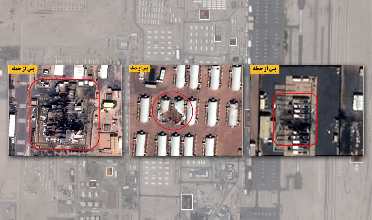
Satellite imagery reveals extensive hits on everything from hangars to fuel depots across the Middle East.
The scope is staggering. Iranian drones and missiles struck bases from Kuwait to Syria, targeting what experts call “soft” infrastructure—barracks, gyms, fuel bladders, communications gear. Nine fuel storage tanks vanished at Kuwait’s Ali al-Salem Air Base. A refueling tanker burned at Saudi Arabia’s Prince Sultan facility.
Patriot and THAAD air defense systems took direct hits in Bahrain and Jordan. This wasn’t random destruction. Iran deliberately avoided “hard” military targets, instead hitting the infrastructure that makes bases livable and operational.
The Human Cost Behind the Strategic Calculations
Seven Americans died while hundreds were injured in strikes that forced base evacuations.
Seven U.S. service members died—six in Kuwait, one in Saudi Arabia. Over 400 were wounded, forcing partial evacuations from multiple facilities. Some bases became uninhabitable, pushing operations into hotels and office buildings.
The 5th Fleet headquarters relocated from Bahrain to MacDill Air Force Base in Florida, potentially permanently. These aren’t abstract military assets—they’re people’s workplaces and living quarters, targeted with precision that surprised defense analysts.
When Commercial Satellites Become Classified
U.S. government requests created an information blackout that Iranian state media eagerly filled.
Planet Labs and Vantor, major commercial satellite providers, restricted Middle East imagery at U.S. government request after March 8th. The stated reason: operational security. The actual result: Iranian state media became the primary source for damage assessment imagery.
The Washington Post verified Iranian-released photos using European Copernicus satellite data, turning adversary propaganda into journalistic fact-checking.
Strategic Miscalculations and Depleted Defenses
Experts say the U.S. underestimated Iran’s drone resilience and precision capabilities.
“Iranian attacks were precise… no random craters,” notes CSIS analyst Mark Cancian. The strikes depleted 53% of THAAD and 43% of Patriot interceptor stocks within weeks—ammunition shortages the Pentagon hoped to avoid after observing Ukraine’s air defense struggles.
CENTCOM disputes calling the damage “extensive” without full context, promising transparency after hostilities end.
The satellite eye in the sky doesn’t wait for official permission to reveal uncomfortable truths. Your government’s credibility gap just became measurable from space.